|
Area:
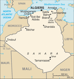
total: 2,381,741 sq km country comparison to the world: 10 land: 2,381,741 sq km water: 0 sq km Area - comparative: slightly less than 3.5 times the size of Texas Land boundaries: total: 6,343 km border countries: Libya 982 km, Mali 1,376 km, Mauritania 463 km, Morocco 1,559 km, Niger 956 km, Tunisia 965 km, Western Sahara 42 km border bodies of water: Mediterranean Sea Coastline: 998 km |
|
|
|
Climate: arid to semiarid; mild, wet winters with hot, dry summers along coast; drier with cold winters and hot summers on high plateau; sirocco is a hot, dust/sand-laden wind especially common in summer Terrain: mostly high plateau and desert; some mountains; narrow, discontinuous coastal plain Elevation extremes: lowest point: Chott Melrhir -40 m highest point: Tahat 3,003 m |
Information found at
https://www.cia.gov/library/publications/the-world-factbook/geos/ag.html
